Citation:
Citation_Information:
Originator: AWS Truewind, LLC
Publication_Date: 2003
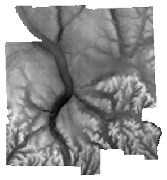
Title: Average Wind Speed at 70m, Tompkins County NY, 2003
Geospatial_Data_Presentation_Form: raster digital data
Publication_Information:
Publication_Place: Ithaca, NY
Publisher: Cornell University Department of Utilities and Energy Management
Description:
Abstract: This file was created using the MesoMap system which consists of an integrated set of atmospheric simulation models, databases, and computers and storage systems. At the core of MesoMap is MASS (Mesoscale Atmospheric Simulation System), a numerical weather model, which simulates the physics of the atmosphere. MASS is coupled to a simpler wind flow model, WindMap, which is used to refine the spatial resolution of MASS and account for simple localized effects of terrain and surface roughness. MASS simulates weather conditions over a region for 366 historical days randomly selected from a 15-year period. When the runs are finished, the results are input into WindMap. Truewind subsequently validates the wind maps. The final product is a grid of cells each containing a single value of average wind speed (m/s) at a hub height of 70 meters, for a 40,000 square meter area.
Purpose: The purpose of creating this file was to use MesoMap to create high-resolution wind resource maps of the state and to provide wind resource data in a format enabling the assessesment potential wind development sites in a GIS. By combining a sophisticated numerical weather model capable of simulating large-scale wind patterns with a microscale wind flow model responsive to local terrain and surface conditions, they enable the mapping of wind resources with much greater accuracy than has been possible in the past. In addition, they do not require surface wind data to make accurate predictions. While on-site measurements will be required to confirm the predicted wind resource at any particular location, mesoscale-microscale modeling can greatly reduce the time and cost required to identify and evaluate potential wind project sites.
Time_Period_of_Content:
Time_Period_Information:
Single_Date/Time:
Calendar_Date: 2003
Currentness_Reference: publication date
Status:
Progress: Complete
Maintenance_and_Update_Frequency: None planned
Spatial_Domain:
Bounding_Coordinates:
West_Bounding_Coordinate: -76.69611
East_Bounding_Coordinate: -76.235723
North_Bounding_Coordinate: 42.626817
South_Bounding_Coordinate: 42.261918
Keywords:
Theme:
Theme_Keyword_Thesaurus: None
Theme_Keyword: wind speed
Theme:
Theme_Keyword_Thesaurus: LCSH
Theme_Keyword: Atmospheric circulation--Computer simulation
Theme_Keyword: atmosphere
Theme:
Theme_Keyword_Thesaurus: ISO 19115 Topic Category
Theme_Keyword: climatologyMeteorologyAtmosphere
Theme:
Theme_Keyword_Thesaurus: CUGIR Category
Theme_Keyword: climate
Place:
Place_Keyword_Thesaurus: LCSH
Place_Keyword: Tompkins County (N.Y.)
Access_Constraints: None
Use_Constraints: This map was created by AWS Truewind using the MesoMap system and historical weather data. Although it is believed to represent an accurate overall picture of the wind energy resource, estimates at any location should be confirmed by measurement. Please cite AWS Truewind, LLC when using these data.
Point_of_Contact:
Contact_Information:
Contact_Organization_Primary:
Contact_Organization: AWS Truewind
Contact_Person: Michael Brower
Contact_Address:
Address_Type: mailing address
Address: 255 Fuller Road, Suite 274
City: Albany
State_or_Province: New York
Postal_Code: 12203-3656
Country: United States
Contact_Voice_Telephone: (518)437-8660
Browse_Graphic:
Browse_Graphic_File_Description: preview of the dataset
Browse_Graphic_File_Type: PNG
Data_Set_Credit: AWS Truewind, LLC
Native_Data_Set_Environment: Microsoft Windows 2000 Version 5.1 (Build 2600) Service Pack 1; ESRI ArcCatalog 8.3.0.800
Distributor:
Contact_Information:
Contact_Organization_Primary:
Contact_Organization: Albert R. Mann Library
Contact_Address:
Address_Type: mailing and physical
Address: Cornell University
City: Ithaca
State_or_Province: New York
Postal_Code: 14853
Contact_Voice_Telephone: 607-255-5406
Distribution_Liability: Cornell University provides these geographic data "as is". Cornell
University makes no guarantee or warranty concerning the accuracy of
information contained in the geographic data. Cornell University further
makes no warranty either expressed or implied, regarding the condition of
the product or its fitness for any particular purpose. The burden for
determining fitness for use lies entirely with the user. Although these
files have been processed successfully on computers at Cornell University,
no warranty is made by Cornell University regarding the use of these data
on any other system, nor does the fact of distribution constitute or imply
any such warranty.
Standard_Order_Process:
Digital_Form:
Digital_Transfer_Information:
Format_Name: GeoTIFF
Format_Information_Content: zipped geotiff
File_Decompression_Technique: zip
Transfer_Size: 0.15
Digital_Transfer_Option:
Online_Option:
Computer_Contact_Information:
Digital_Form:
Digital_Transfer_Information:
Format_Name: metadata
Format_Information_Content: FGDC XML metadata
Digital_Transfer_Option:
Online_Option:
Computer_Contact_Information:
Digital_Form:
Digital_Transfer_Information:
Format_Name: HTML metadata
Format_Information_Content: FGDC HTML metadata
Digital_Transfer_Option:
Online_Option:
Computer_Contact_Information:
Digital_Form:
Digital_Transfer_Information:
Format_Name: OGC:WMS
Format_Information_Content: WMS, from GeoServer
Digital_Transfer_Option:
Online_Option:
Computer_Contact_Information:
Fees: None
Metadata_Date: 20190604
Metadata_Contact:
Contact_Information:
Contact_Organization_Primary:
Contact_Organization: Albert R. Mann Library
Contact_Address:
Address_Type: mailing and physical
Address: Albert R. Mann Library
City: Ithaca
State_or_Province: New York
Postal_Code: 14853
Country: USA
Contact_Voice_Telephone: 607-255-5406
Metadata_Standard_Name: FGDC Content Standard for Digital Geospatial Metadata
Metadata_Standard_Version: FGDC-STD-001-1998
Metadata_Time_Convention: local time